
Chapter 12: Urban and Suburban Spaces
12.2 Urban Spaces – A Sense of Place
12.2.1 The City as Place
In one way, cities are vast, complex machines that produce goods and services, but that way of conceiving the city overlooks very real emotional qualities that define almost any location. Most people would argue that cities have personalities; qualities that define them as a place. People who live in particular cities often develop a sort of tribal attitude toward their city. This attitude is reflected most visibly in the very real, emotional attachment citizens have to their sports teams. It’s not uncommon for citizens of a city to take great offense at derogatory remarks directed toward “their city”, especially if those remarks come from an outsider.
How we know what we know about cities is largely bound up in symbolisms of cities provided us through countless media. Often people have enormous storehouses of knowledge about specific places (New York, Paris, Hollywood), even though they have never even visited. We also have powerful ideas about generic places, “small towns”, “the suburbs”, “the ghetto”, even though we may not have visited these places either. Clearly, this knowledge is imperfect and may very well be dangerously inaccurate to both us and those people who live in these places. It’s important that we recognize how our knowledge of places has been constructed and we must seek to understand what purposes these constructions serve.
Geographer Donald Meinig proposed that Americans have particularly strong ideas and emotions about three special, but generic landscapes: The New England Village, Small Town America and the California Suburb (Meinig’s Three Landscapes). Scholars who specialize in the theory of knowledge would suggest these are landscapes are “always already” known; because the symbolism associated with them is deeply engrained in our collective thoughts, despite that fact that we are hard pressed to identify how we came to understand the symbolism associated with these places.
Meinig’s first symbolic landscape is the sleepy New England Village, with its steepled white church and cluster of tidy homes surrounded by hardwood forests is strongly evocative of a lifestyle centered around family, hard work, prosperity, Christianity and community. He called its rival from the American Midwest Main Street USA. This landscape is found in countless small towns, and symbolizes order, thrift, industry, capitalism and practicality. It’s less cohesive and less religious than the New England Village, and more focused on business and government. Finally, Meinig points to the California Suburb as the last of the major urban landscapes deeply embedded in the national consciousness. Suburban California symbolizes the good-life: backyard cookouts with the family and neighbors, a prosperous, healthy lifestyle, centered on family leisure.
So powerful are these images that they often appear as settings for novels, movies, television shows as well as political or product advertising campaigns. If you were a manufacturer of high quality home furnishings, you may want to use the landscape of New England to help sell a well-built dining room table. Insurance companies, like to evoke images of Main Street USA when they want to sign you up for a policy; “like a good neighbor” they might tell you, hoping you’ll trust the company, despite the fact that its headquarters is not in a small farming town. E.T., the famous movie about a boy who befriends a lost space alien is set in a “typical California suburb”. Like the other symbolic landscapes, movie audiences do not need to have the setting explained to them, they always already know what that place means. Certainly, there are other symbolic landscapes.
12.2.2 A Global Sense of Place
A major objective for this chapter is the creating of an understanding of the relationality and territoriality of cities; that is, understanding how cities exist in what geographer Doreen Massey in 1991 calls a “global sense of place.[1]” We will also explore how cities are related to other places, and how cities are at the same time unique places as explained in the section above.
The concept of a global sense of place has three characteristics:
- Places have multiple identities and meanings. The meaning is dependent on the people who are experiencing a place.
- Places are more than physical locations; they are made up of processes.
- Places are not static, they are ongoing and ever changing because of relationships to other places.
A global sense of place means viewing every city as globalized or worldly precisely because of its relationship to other places, and the mobile processes that are ongoing in places. Likewise, a global sense of place means that the territoriality, or what makes a place unique, can be understood because other places are different.
12.2.3 What is a City?
A city, in its most basic sense, is a constellation of people and social, political and economic institutions and infrastructures within a physical location. While there is usually no agreed-upon population or socio-economic configuration for most cities, they are nevertheless understood to be discrete locations that are governed by political institutions (e.g., a municipal government with a mayor and city council), and city governments have the power to make laws and collect taxes from the people and businesses that inhabit it. Cities of course, do not exist in isolation from other places. They are connected to places near and far, to other cities and to rural communities and landscapes.
Cities are created through processes of urbanization, which combine various socio-economic, political, technological, and environmental processes that affect the way that cities are made up and how people live in them. The graph below demonstrates how countries such as the United States with an early onset of the industrial revolution experienced rural-to-urban migration seeing about an even 50/50% split of urban and rural residents in the 1920s. For a better close-up view of the graph (Figure 12.2.1) below please click on the graph below or visit it on the Urbanization in the United States 1790 to 2050 graph on the Statista website.
),_OWID.svg#/media/File:Urban_and_rural_populations_in_the_United_States_(US_Census_Bureau_(1790_to_2010)),_OWID.svg)
Source: “Urban and rural populations in the United States (US Census Bureau (1790 to 2010)), OWID” by Our World In Data via Wikimedia Commons is licensed under CC BY 3.0.
Must of us are “city people,” whether we like it or not. Many people say they do not like the city, with its noise, pollution, crowds, and crime, but living outside the city has its challenges as well. Living outside a city is inconvenient because rural areas lack access to the numerous amenities found in cities. The clustering of activities within a small space is called agglomeration, and it reduces the friction of distance for thousands of daily activities. Cities are convenient places for people to live, work, and play. Convenience has economic consequences, as well. Reduced costs associated with transportation, and the ability to share expenses for infrastructure creates what is known as economies of agglomeration, which is the fundamental reason for cities. The convenience and economic benefits of city life have led nearly 8 in 10 Americans to live in urban areas. In California, America’s most urban state, almost 95% of its people live in a city. We will explore the evolution of cities, why cities are where they are, and how the geography of cities affects the way urbanites live.
Though it seems simple enough, distinguishing cities from rural areas is not always that easy. Countries around the world have generated a plethora of definitions based on a variety of urban characteristics. Part of the reason stems from the fact that defining what constitutes urban is somewhat arbitrary. Cities are also hard to identify because they look and function quite differently in different parts of the world. Complicating matters are the great variety of terms we use to label a group of people living together. Hamlets are tiny, rural communities. Villages are slightly larger. Towns are larger than villages. Cities are larger than towns. Then there are words like metropolis and even megalopolis to denote huge cities. Some states in the United States have legal definitions for these terms, but most do not. The United States Census Bureau creates the only consistent definition of “city,” and it uses the terms “rural” and “urban” to distinguish cities from non-city regions. This definition has been updated several times since the 1800s, most radically in recent years as the power of GIS has allowed the geographers are working for the U.S. Census Bureau to consider multiple factors simultaneously.
For decades, the US Census recognized an area as “urban” if it had incorporated itself as a city or a town. Incorporation indicates that a group of residents successfully filed a town charter with their local state government, giving them the right to govern themselves within a specific space within the state. Until recently, the US Census Bureau classified almost any incorporated area with at least 2,500 people as “urban.”
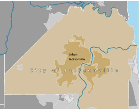
Source: “Figure 7.2 Jacksonville, FL” in Human Geography: An open textbook for Advanced Placement by the Puyallup School District is in the Public Domain.
There were problems though with that simple definition. Some areas which had really quite large populations but were unincorporated, failed to meet the old definition or urban. For example, Honolulu, Hawaii, and Arlington, Virginia are not incorporated, therefore were technically labeled “census designated places,” rather than cities. Conversely, some incorporated areas may have very few people. This can happen when a city loses population, or when the boundaries of a city extend far beyond the populated core of the city. You may have witnessed this as you are driving on a highway, and you see a sign indicating “City Limits,” but houses, shops, factories and other indicators of urban life are absent yet for many miles.Jacksonville, Florida is a classic example of this problem. Jacksonville annexed so much territory that its city limits extend far into the adjacent countryside making it one of the largest city in land area in the contiguous United States (874.3 square miles!).
- Massey, D., 1991,A global sense of place. Marxism Today (38) 24-29 SENSE OF PLACE = IDENTITY OF PLACE. Retrieved on July 25, 2024: ↵
