
Chapter 6: The Geography of Language
6.6 Toponyms – Place Names
6.6.1 An Attempt at Toponymy Categorization
Toponyms are the names we give to places, ranging from vast areas like “Canada”[1] to small locations like “Main Street.” When carefully analyzed, toponyms can reveal insights about the history of a place, where the settlers came from, what language the early settlers spoke. and sometimes their religious leanings.
Many of the place names found in the United States can be classified in terms of the following major categories:
- natural landscape features – hills/mountains, rivers, valleys, deserts, coastline like Blue Ridge Mountains,
- urbanized areas – cities, towns, and streets like Martin Luther King, Jr. Drive, Williamsburg, VA
- directional place names – East, North, South, West such as North & South Dakota, West Virginia,
- religious significant names – saints, Biblical names such as San Antonio, Santa Fe, St. Louis,
- explorers and colonizers – French, English, Spanish, Dutch setters such as Columbus, OH; Coronado, CA
- famous persons -presidents, politicians, Native Americans such as Washington, D. C.; Jackson, MS; Tuscaloosa,
- culturally based names – immigrant’s homeland, famous locations such as New Orleans; New Mexico; New Amsterdam, NY; Troy, NY; Rome, GA
- business oriented names – wealthy individuals, politicians, corporate sponsors such as Sears Tower, Trump Tower, Verizon Center

Source: Photo by Barbara Crain, CC BY 4.0
Located near the college town of Ann Arbor in southeast Michigan, Hell is a relatively typical township with an unusual name that dates back to 1841. One wonders into which of the above categories this name would fit–maybe a ‘directional place name’?
According to an Atlas Obscura publication, there are several theories regarding the origin of the town’s name. The most plausible (though least amusing) explanation is that it came from a pair of visiting Germans in the 1830s who described the area as “so schön hell” (“so beautifully bright”). Another theory involves the town’s founder, George Reeves, who allegedly said, “I don’t know, you can name it Hell for all I care,” when asked what to call the new settlement. There is also a story that Reeves, who owned a general store and grist mill, paid farmhands in whiskey, causing their wives to lament that their husbands had “gone to Hell again” when they failed to return for dinner. Lastly, some suggest the name arose from the swampy, mosquito-infested conditions that early settlers encountered before the town was officially established.
Source: Photo by Barbara Crain, CC BY 4.0.
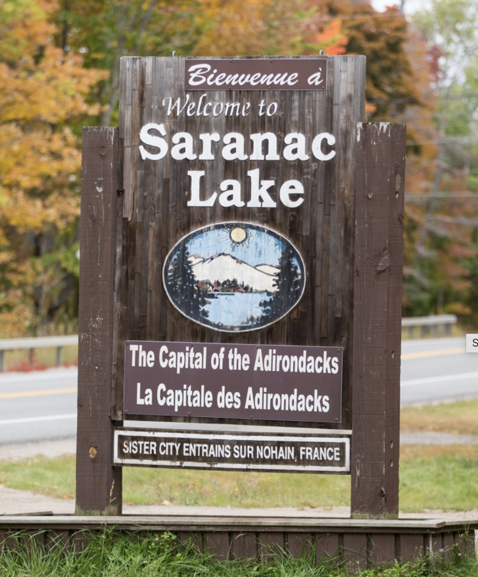
Many toponyms in North America originate from Native American languages, and as a result, the meanings of these place names often elude us. Take the town of Saranac Lake in the Adirondacks. Saranac is an Abenaki[2]word meaning ‘staghorn sumac cone’. The term ‘Adirondacks’ is equally interesting as according to Britannica it means ‘eater of tree bark’ which is derived from an Iroquois word; a derisive term bestowed by the Iroquois upon their neighboring Algonquin tribe. Clearly this wouldn’t fit into any of the categories listed above.
Many city and town names are compound words combining a generic term and a specific one. For instance, names like Charleston, Boston, and Newton include the suffix “-ton,” indicating “town.” Therefore, “Charleston” can be interpreted as “Charles’ Town,” named after King Charles II of England. This analysis shows that the city was founded by English speakers who admired the king, and that it was established before the American Revolution. On the other hand, Charleston, West Virginia, founded around the American Revolution, also uses the English suffix “-ton” because its founders were English speakers.
Immigrant groups brought their own generic terms for “town” to the US. For example, German settlers often used the suffix “-burg,” resulting in town names like Pittsburgh, Harrisburg, and Gettysburg in Pennsylvania or Fredericksburg in Virginia. The suffix “-burgh” in Pittsburgh likely evolved from the word “borough,” influenced by German settlers. German and English are closely related, making such linguistic adaptations common. Additionally, many US towns are named after German cities, such as Hanover, Berlin, and Hamburg. And then there is Germanna in Virginia, north of Fredericksburg.
The French and Spanish settlers also left their mark on North America. Both Catholic groups frequently named towns after saints, such as St. Louis (French) and San Diego (Spanish). The French often used the suffix “-ville,” as seen in Louisville, and many French toponyms are found in Louisiana. Other cities with French names include Detroit, St. Louis, and Des Moines. Spanish toponyms are prevalent in the American Southwest as are many Native American names.
Interestingly, toponyms from some other immigrant groups are less common. Russians, Poles, and Italians, who immigrated later, had fewer opportunities to name places. African toponyms are almost nonexistent in the US due to the lack of power among Africans upon their arrival. In contrast, Native American toponyms are widespread, reflecting the names of physical features like rivers, mountains, and valleys, with well-known examples including Chicago, Milwaukee, and Seattle.
6.6.2 Renaming Place
Toponyms then, including place names, street names, plaza names, and school names are an element of a cultural landscape and contribute to the overall place-identity of a location. Language is a form of and canvas for power and power is exercised from above and below, equally including efforts to enforce authority and contest authority. The change of Burma to Myanmar and Zaire to Congo are two relatively recent example of changes due to political developments.
We can see what this looks like on the ground by analyzing some examples of naming and re-naming or un-naming. Check out the links below:
- Swaziland becomes eSwatini.
- Former Yugoslav Republic of Macedonia becomes Republic of North Macedonia.
- Robert E. Lee High School in Springfield, VA to get a new name
The first example reflects a trend among formerly colonized places to re-name places based on languages and systems of meaning that pre-date colonial influence. Re-naming, thus, is a way to symbolically and sometimes materially throw off or reject colonial power, possession, influence, and identity. The second example illustrates how naming is deeply and inherently tied to cultural, national, and place identities.
The third example may strike much closer to home, literally, and illustrates how the choice or avoidance of certain names and words themselves is a way to signal allegiance with or distance from widely perceived meanings of those names. Controversies surrounding the changing of names (not to mention removing statues as it happened on Monument Avenue in Richmond, VA), in these cases, associated with the Confederacy in the US, abound among everyday individuals, public historians, businesses, and local, state, and national governing bodies and policy-makers. The controversies are based around language–a system of communication that produces meaning.
We as individuals and a society have to determine which particular words and symbols we want to be associated with and accept, reject, or re-interpret popular and contemporary meanings of said words and symbols. The process is and should be continuous.
6.6.3 Toponyms Given on Maps by Outsiders

Source: “Gliederung des Bodensees.png” by Thoroe via Wikimedia Commons is licensed under CC BY-SA 3.0.
Since name-giving is such an important part of cultural identity, why do some cultures refer to, say, physical features that are part of another culture’s territory by giving it different names? One such instance is the name given to the largest lake in Germany and Europe’s third largest lake-the Bodensee. In English the lake is called Lake Constance. The term Bodensee has its roots in or even before the 9th century and was named after an aristocratic dignitary – Graf Bodman, a count. The family lineage still exists; in fact the present count was interviewed to provide an overview of the naming of the lake. Have a look at this article, Wie der Bodensee zu seinem Namen kam. While it is in German, the photos and their titles are quite revealing (nice castles, too). Clearly the lake’s name suggests great cultural identity. Yet, why is the lake referred to as Lake Constance in English? It is named after the largest town on the lake – Konstanz,-itself of Latin Origin as the Romans established here Constantia, a military fortress.
Sometimes such name changes may have their origin in people’s inability to hear and pronounce the original name correctly. Sometimes it may jar people’s memory if the name of a larger settlement appears in the name as is the case with the Bodensee. Sometimes it is colonial thoughtlessness and sometimes it is a blatant political power game.

Source: “Northern Europe November 1939.png” by Peltimikko is in the public domain.
Other examples involve physical features named according to their orientation on the map. For instance, the Baltic Sea is referred to as the East Sea by Germans and neighboring countries like Sweden, Norway, and Denmark. Estonia calls it West Sea. France, Russia and the British call it Baltic Sea presumably because the Baltic[3] states are bordering it.
The North Sea depicted in Figure 6.6.5 is located east of Britain but north of the Netherlands and other European countries notably Germany, France and Belgium. It derived its name from the Dutch Noordzee. In English is was long called German Ocean.

Source: “Europe topography map de.png” by San Jose via Wikimedia Commons is licensed under CC BY-SA 3.0.
In the United States the U.S. Board on Geographic Names ((BGN)- a Federal Body – was established in 1890 to maintain uniform geographic name usage throughout the Federal Government. A United Nations Group of Experts on Geographical Names (UNGEGN) has at its core the task to establish a national geographical names authority or institution for countries. An effective standardization program is understood to be crucial for enabling accurate and efficient administration nd clear communication.
Sometimes it can become cantankerous when neighboring countries that share a certain physical feature such as an ocean or a sea cannot agree on the name that is to be used on an international map. Here are some examples where states have a hard time compromising:
Persian Gulf or Arabian Gulf?

Source: “Hormuz map.png” by Kleptosquirrel via Wikimedia Commons is licensed under CC BY-SA 3.0.
The naming controversy between the Persian Gulf and the Arabian Gulf centers on geopolitical and cultural disputes over the body of water between Iran and the Arabian Peninsula. Historically known as the Persian Gulf, this name is supported by Iran and has ancient roots in Greek and Roman texts. Iran views the use of alternative names as an affront to its cultural heritage.On the other hand, some Arab countries prefer the name Arabian Gulf, arguing it reflects the region’s geographic and demographic realities, particularly the Arab nations along the gulf’s shores. This naming preference gained traction in the mid-20th century with the rise of Arab nationalism. The dispute is deeply tied to national identities and regional politics, with each term symbolizing broader tensions between Iran and its Arab neighbors.
The Sea of Japan or East Sea?
The controversy over the naming of the sea between the Korean Peninsula and Japan revolves around whether it should be called the “Sea of Japan” or the “East Sea.”
Sea of Japan:
- The name “Sea of Japan” is widely used internationally and has been the dominant term on most global maps since the early 19th century. Japan supports this designation, arguing that it has been the established name recognized by international organizations such as the International Hydrographic Organization (IHO) and the United Nations.
East Sea:
- South Korea advocates for the name “East Sea,” asserting that this has been the traditional Korean name for the body of water for over 2,000 years. South Korea contends that the widespread adoption of “Sea of Japan” occurred during the early 20th century, when Korea was under Japanese colonial rule, thus reflecting a period of historical subjugation.
Geopolitical and Cultural Implications:
- The naming dispute is not just a matter of semantics but is deeply intertwined with issues of national identity, historical memory, and regional politics. South Korea views the continued use of “Sea of Japan” as a lingering vestige of colonialism and seeks international recognition for “East Sea” to rectify what it sees as historical injustice.
- Internationally, maps and documents sometimes use both names to acknowledge the sensitivities of both sides, but the disagreement remains a point of diplomatic friction between South Korea and Japan. Efforts to reach a consensus have so far been unsuccessful, with both countries continuing to strongly advocate for their preferred terminology.
Yellow Sea and West Sea
The naming controversy over the Yellow Sea involves China and South Korea’s differing perspectives.
Yellow Sea:
- China supports the name “Yellow Sea,” derived from the Yellow River’s sediment and historically used in Chinese and Western maps.
West Sea:
- South Korea refers to it as the “West Sea” (Seohae), reflecting its geographical position west of the Korean Peninsula and emphasizing Korea’s historical ties to the region.
Implications:
- This dispute reflects national identities and historical narratives, with China favoring “Yellow Sea” for its historical accuracy, while South Korea promotes “West Sea” to honor its cultural heritage. International maps often use “Yellow Sea,” but there is increasing recognition of the Korean perspective, sometimes resulting in dual naming.
Other Examples Include:
Taiwan: due to political sensitivities, Taiwan is often referred to as “Chinese Taipei” in international contexts, particularly in sporting events and organizations, to avoid offending China, which considers Taiwan part of its territory;
South China Sea: everal countries, including China, the Philippines, Vietnam, Malaysia, Brunei, and Taiwan, have competing claims over parts of the South China Sea. The naming and territorial disputes are linked to control over maritime resources and strategic navigation routes.
Aegean Sea: Greece and Turkey have disputes over the naming and territorial rights in the Aegean Sea. The conflict includes issues related to airspace, territorial waters, and maritime boundaries.
Some Resolutions:
North Macedonia/Macedonia: The naming dispute between Greece and the country formerly known as the Former Yugoslav Republic of Macedonia (FYROM) was a longstanding issue. Greece opposed the use of the name “Macedonia” because it is also a region in northern Greece with historical significance. In 2019, the country officially changed its name to North Macedonia as part of the Prespa Agreement to resolve the dispute.
Denali/McKinley: In the United States, the highest peak in North America was officially named Mount McKinley after President William McKinley, but it has been known as Denali by the indigenous Koyukon Athabaskan people. In 2015, the U.S. government officially restored the name Denali.
- According to the Government of Canada The name "Canada" likely originates from the Huron-Iroquois word "kanata," which means "village" or "settlement." In 1535, two Aboriginal youths informed French explorer Jacques Cartier about the route to kanata, referring to the village of Stadacona, the present-day site of Québec City. With no other name available, Cartier used "Canada" to describe both the village and the surrounding territory governed by its chief, Donnacona. The name quickly expanded in scope; by 1547, maps labeled all the land north of the St. Lawrence River as Canada. ↵
- According to Wikipedia the Abenaki are an Indigenous people of the Northeastern Woodlands of Canada and the United States. They are an Algonquian-speaking people and part of the Wabanaki Confederacy. The Eastern Abenaki language was predominantly spoken in Maine, while the Western Abenaki language was spoken in Quebec, Vermont, and New Hampshire. ↵
- I found it very difficult to get to the etymology of the term 'Baltic' from a reliable source. According to Online Etymology Dictionary it may mean white or strait, belt. ↵
