Chapter 1: Introduction to Geography
1.5 Place as Unique Location
1.5.1 A Sense of Place
Humans possess a strong sense of place, which is not only a recognition of the physical features that make a particular location unique but also an emotional attachment to these places. This feeling for the distinctiveness of a spot on Earth can encompass personal connections such as a hometown, a cherished vacation destination, or a beloved part of a country. These emotional bonds are deeply tied to our memories, experiences, and personal histories, making certain places hold a special significance beyond their geographical attributes. Describing such features of place is an essential building block for geographers to explain similarities, differences, and changes across Earth. Geographers think about where particular places are located and the combination of features that make each place on Earth distinct.
We also form perceptions of places we have never been to through reading books, watching movies, hearing stories, and seeing pictures, shaping our opinions based on these virtual or real experiences. For example, many people who have never visited Paris might envision it as a romantic and picturesque city, influenced by movies like “Midnight in Paris” or books like “The Da Vinci Code.” These portrayals create a mental image of Paris filled with iconic landmarks like the Eiffel Tower and charming street cafes, even if the reality might include crowded streets, smelly alleys, homeless people underneath the bridges and daily routines. This demonstrates how media and stories shape our perceptions of places and contribute to our understanding and expectations of them.
Place names, or toponyms, are integral to the sense of place as they encapsulate the identity, history, and cultural significance of a location. They serve as a reference point for understanding the unique characteristics and heritage of a place. For example, the name “New York” evokes images of towering skyscrapers, bustling streets, and cultural landmarks like Times Square and Central Park. Similarly, names like “Machu Picchu” or “Ganges River” immediately connect us to the ancient Incan civilization and sacred Hindu practices, respectively.
Place names also reflect the linguistic, historical, and cultural narratives of a region, contributing to a deeper connection and understanding of the place. They often tell stories of the people who lived there, significant events that occurred, and the natural features that define the area. For instance, the above example of “Machu Pichu” that connects us to the Incan civilization may connect us even better by knowing that the Quechuan meaning of the name is “Old Mountain”. By recognizing and using these names, geographers and individuals alike can appreciate the rich tapestry of meanings and associations that contribute to the sense of place.
1.5.2 Site and Situation
Site refers to the physical characteristics of the location where a settlement or structure exists. These characteristics can include the landforms, climate, vegetation, water resources, and soil quality of the area. For instance, the site of New York City includes its position on the Hudson River, its coastal location, and the natural harbor provided by the Atlantic Ocean. Understanding the site helps explain why a location was chosen for settlement or development and how its physical environment has influenced its growth and development.
Situation, in contrast, refers to the location of a place relative to its surroundings and its connections to other places. It involves the place’s accessibility, proximity to resources, and its significance in relation to other locations. For example, New York City’s situation is advantageous due to its strategic position as a gateway for international trade, its extensive transportation networks, and its role as an economic and cultural hub. While site focuses on the inherent physical attributes of a place, situation emphasizes its external relationships and functional importance in a broader spatial context.

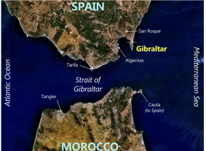
Source: “Gibraltar World Wind view annotated.jpg” by NASA World Wind (image), Prioryman (annotations) via Wikimedia Commons is licensed under CC0 1.0 Universal.
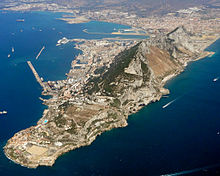
Another example of how the terms “site” and “situation” are used can be demonstrated with the map in Figure 1.5.1, which shows Gibraltar at the center. The situation of Gibraltar refers to its location in the Mediterranean Sea, at the southern tip of Spain, near Morocco, and close to the Strait of Gibraltar. This strategic location allows control over maritime traffic entering and exiting the Mediterranean. The site of Gibraltar, on the other hand, includes its physical characteristics such as being a peninsula with significant strategic importance for naval operations. Additionally, Figure 1.5.2 highlights the massive rock formation, another notable site feature of Gibraltar.

Source: “Gibraltar aerial view looking northwest.jpg” by Steve via Wikimedia Commons is licensed under CC BY-SA 2.0.

