
Chapter 1: Introduction to Geography
1.2 The Discipline of Geography
1.2.1 What is Geography?
The Greek word geographos from which geography is derived, is literally translated as writing (graphos) about the Earth (geo). Geography differs from the discipline of geology because geology focuses mainly on the physical Earth and the processes that formed and continue to shape it. In contrast, geography involves a much broader approach to examining the Earth, as it involves the study of humans as well. As such, geography has two major subdivisions, those of human geography (social science) and physical geography (natural science). This text focuses primarily on human geography, but because the physical aspects affect humans and vice versa, physical geography will not be completely excluded, but will receive less emphasis.
Geography is the study of the physical and environmental features of the world, analyzed through a spatial perspective. It is this spatial perspective that make the discipline unique..It involves displaying the phenomena under study on a map, allowing geography to focus on locations around the world. Questions commonly asked in the discipline are, “What is where, and why?” In general, human geography focuses on people, where they live, their ways of life, and their interactions in different places around the world. A simple example of a geographic study in human geography might ask where the Hispanic population is concentrated in the U.S. and why. In physical geography, a research question could be where most hurricanes strike the U.S. coastline and why. Additionally, since the Earth is dynamic, geographers examine how places change over time and why, naturally connecting geography with history.
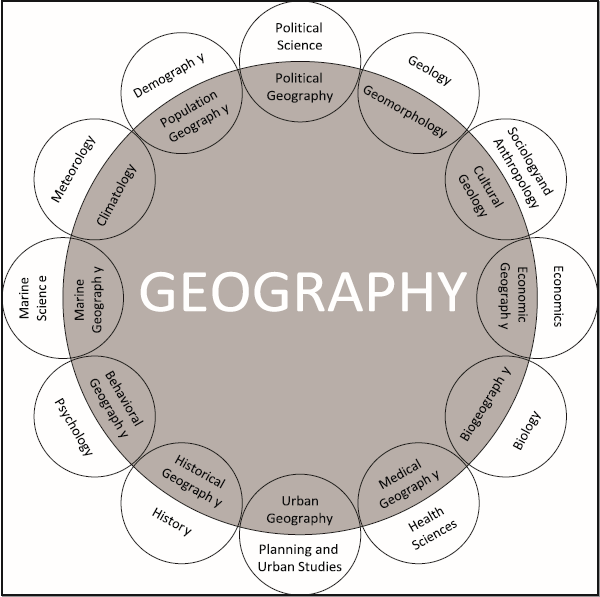
“Geography Relationships” by Corey Parson via the open book “Introduction to Human Geography” is licensed under CC BY-SA 4.0.
Not only is there a connection between geography and history, but geography is also related to a broad range of other academic disciplines (Figure 1.2.1 above). If a phenomenon can be depicted on a map and studied from a spatial perspective, it is geographical. A basic example would relate to the health sciences or medical geography, the subfield of geography that focuses on the spatial patterns of various aspects of health. For example, when the spread of a disease from its source area is mapped, medical professionals can get a better idea of the causes of a disease and the mechanisms of its transmission. Often, the understanding of cultural practices or the environmental conditions (such as the habitat for a mosquito-borne disease) can shed light on the process of how the disease operates.
It can also aid in tracking new diseases to areas where there were not present before due to the changing climate. Germany is experiencing a rise in malaria cases, a situation that is quite unusual for a country with a temperate climate where malaria is not endemic. This increase in cases has been linked to several factors, including climate change, international travel, and the presence of malaria-carrying mosquitoes. As the climate warms, the habitats suitable for mosquitoes that carry malaria are expanding, increasing the likelihood of these insects surviving and breeding in regions where they previously could not. Additionally, the high volume of international travel means that individuals infected with malaria in endemic regions can bring the disease to Germany. The increase in malaria cases is prompting people to invest in screening their windows.
Another example of how geography relates to other disciplines is in economic geography, the subfield that examines the different economic activities in various places, and how places interact economically. A fundamental concept in economic studies is the significance of a business’s location to its success. If a business is situated near its clientele, customers are more likely to visit regularly. Therefore, a business owner should consult maps of transportation networks and the population of their target customers before investing.
1.2.2 The Three Branches of Geography
The UNESCO Encyclopedia of Life Support Systems categorizes geography into three main areas: human geography, physical geography, and technical geography. Some sources simplify this by focusing on just two principal branches: physical and human geography. Geographers typically don’t limit themselves to one category, often using one as a primary focus while integrating data and methods from the other areas. When explaining their work to people outside the field, geographers usually identify closely with a specific branch or sub-branch of geography.
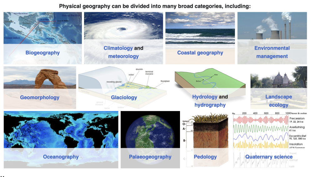
Generally, physical geography is concerned with the study of processes and patterns in the natural environment like the atmosphere, hydrosphere, biosphere, and geosphere. Within physical geography, the main sub-disciplines are: biogeography (the study of the spatial distribution of plants and animals), climatology (the study of climate), hydrology (the study of water), and geomorphology (the study of Earth’s topographic features). This list is not inclusive, however. Some geographers study geodesy, the scientific measurement and representation of Earth. Others study pedology, the exploration of soils. What unites physical geographers is an emphasis on the scientific study of the physical features of Earth in all of its many forms.
Source: A screenshot of the Wikipedia website.
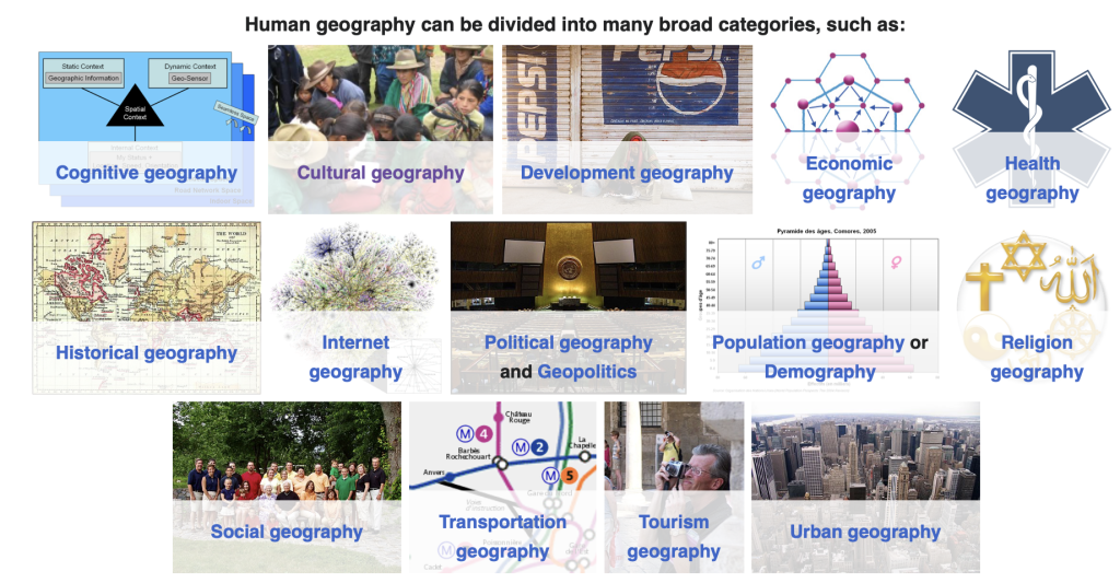
Human geography studies people and their communities, cultures, economies, and environmental interactions by studying their relations with and across space and place (this is what this textbook and course concentrate on). Human geography, too, consists of a number of sub-disciplines that often overlap and interact. The main sub-disciplines of human geography include: cultural geography (the study of the spatial dimension of culture), economic geography (the study of the distribution and spatial organization of economic systems), medical geography (the study of the spatial distribution of health and medicine), political geography (the study of the spatial dimension of political processes), population geography (also known as demography, the study of the characteristics of human populations), and urban geography (the study of urban systems and landscapes). Human geographers essentially explore how humans interact with and affect the earth.
Source: A screenshot of the Wikipedia website.
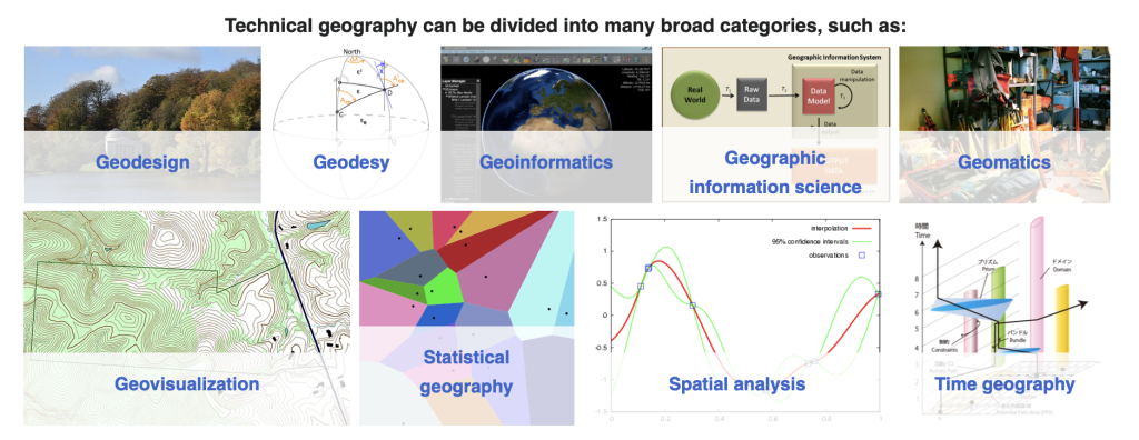
Technical geography is interested in studying and applying techniques and methods to store, process, analyze, visualize, and use spatial data. Of these, Geographic information systems is probably the most known area.
Source: A screenshot of the Wikipedia website.
1.2.3 The Geographic Grid and Finding Location
Location refers to the specific point or area on the Earth’s surface where something is situated. In geography, location is often described in two primary ways: absolute location and relative location.

Source: “FedStats Lat long.svg” by Unknown author via Wikipedia is in the public domain in the United States because it is a work prepared by an officer or employee of the United States Government as part of that person’s official duties.
Absolute location is a precise and fixed point, usually given in terms of coordinates like latitude and longitude. Latitude and longitude are a coordinate system that divides the Earth into a grid, allowing for precise location measurements. Latitude lines run horizontally around the Earth and measure the distance north or south of the Equator, which is 0° latitude. Longitude lines run vertically and measure the distance east or west of the Prime Meridian, which is 0° longitude, located in Greenwich, England. (see Figure 1.2.5) For example, the absolute location of the Eiffel Tower in Paris is approximately 48.8584° N latitude and 2.2945° E longitude. This method of describing location is exact and does not change, providing a unique address for any place on Earth.
GPS uses the concepts of latitude and longitude to pinpoint locations. The Global Positioning System (GPS) is a satellite-based navigation system that allows users to determine their precise location anywhere on Earth. GPS functions by using a network of at least 24 satellites orbiting the Earth, each equipped with an atomic clock to provide accurate time information. The satellites continuously transmit signals that include their current time and position. A GPS receiver on the ground picks up signals from at least four of these satellites to calculate its own position. When a GPS receiver calculates its position, it uses the time delay of the received signals from the satellites to determine its distance from each satellite. By applying a process called trilateration, the receiver calculates its position by finding the intersection of the distances from multiple satellites. This position is then expressed in terms of latitude and longitude coordinates, allowing the user to know their exact location. The accuracy of GPS is typically within a few meters, making it an essential tool for navigation, mapping, and many other applications.
Source: Photo by Barbara Crain, CC BY 4.0.
Source: Photo by Barbara Crain, CC BY 4.0.
Relative location, on the other hand, describes a place’s position in relation to other locations. This could include directions, distances, or descriptive landmarks. For instance, one might say that the Eiffel Tower is located near the River Seine, northwest of the Louvre Museum. Relative location is useful for understanding how a place is connected to or positioned relative to other places and can change depending on the context or perspective. Together, absolute and relative locations provide comprehensive ways to describe and understand the positioning of places on Earth.
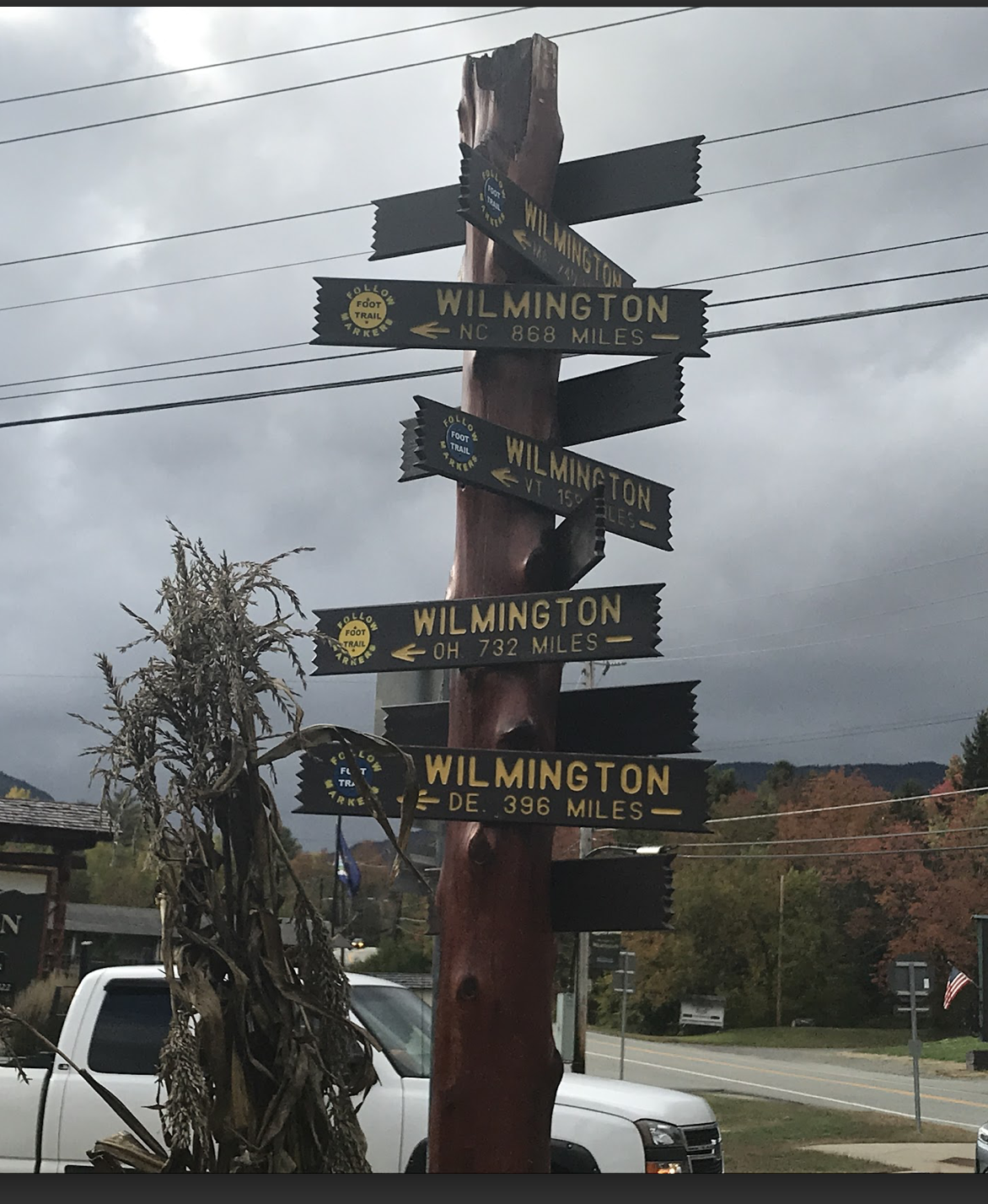
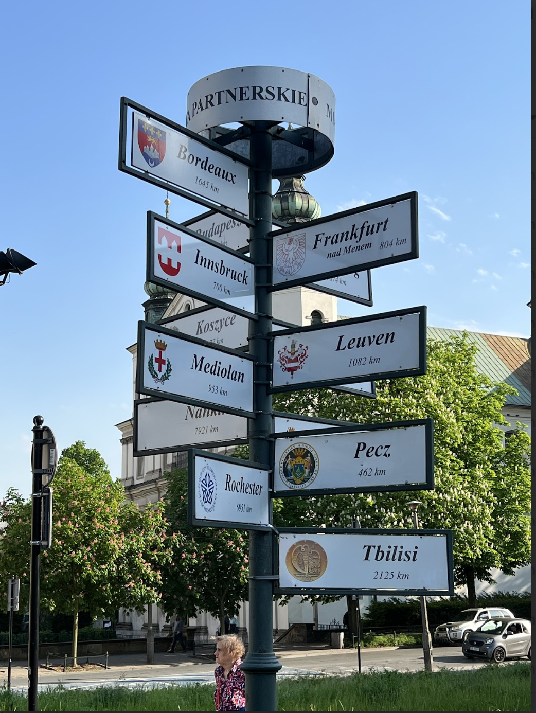
Signs such as Figures 1.2.6 and 1.2.7 providing known reference names and their distances from where the pole is located show the common interest in such knowledge of relative location. And while the sign in Wilmington, NY (located in the Adirondacks Mountains close to Whiteface Mountain, a renowned ski area) might not mean much to the casual observer, the fact that there are so many different locations named ‘Wilmington’ (in OH, NC, DE) is definitely of interest.
1.2.4 GIS (Geographic Information Systems)
GIS stands for Geographic Information Systems and is foundational to Geoinformation Science (GIScience). What is it? It’s a technically advanced way of making in-depth maps by layering together data. Imagine a double-decker peanut butter and jelly sandwich, but instead of the traditional ingredients, the layers are:
- groundcover
- streams
- streets
- above-ground electrical lines
- infrastructure
Now smash all those layers together like a good sandwich and you have replicated in a very rudimentary way how GIS creates a composite view of place.
1.2.5 Remote Sensing
When you cannot be in a particular place and collect data on the ground, you can collect it from above ground by using remote sensing technologies. Remote sensing refers to collecting data from afar. This is typically achieved through cameras, videos, and sensors attached to aircraft including airplanes, satellites, and drones.
Remote sensing provides a wonderful way to gather information about the Earth’s surface and allows us to track landscape change over time.
Exercise: Identifying Landscape Change
Peruse the before and after landscape changes profiled in these USGS Earthshots cards.
Learn more about what geoinformation technologies can do in practice in the video below.
1.2.6 Qualitative analysis of interviews, surveys, and texts
This is human geography, after all, so we definitely don’t want to forget that people themselves have a lot to teach us about the world and their words, stories, and experiences certainly help geographers answer “What is where, why there, and why care?” (Gritzner, 2000).
What might a geographer use?
- Interviews where a researcher asks either a set of closed (yes/no, etc) or open-ended (no answer choices given) questions
- Surveys where a researcher sends a questionnaire to a set of people to learn about their experience or perception of the phenomenon being studied
- Texts where a researcher may review old maps and documents in an archive, environmental impact statements outlining the existing natural and cultural resources of an area, etc.
The data collected is qualitative in nature, meaning it is based around words. Once the stories and experiences of place-based research questions are gathered, the researcher will analyze them by categorizing the data across all sources into themes and even quantify the relative presence of the themes in comparison to each other.
To build upon the example above of a map that coded indigenous land as terra nullius, you can imagine how talking to indigenous people about their own perceptions of that place and the values and meanings that the land has for them, would significantly add to our overall geographical knowledge and understanding of the world. It would also have implications for policies on how to manage the land.
