
Chapter 9: Political Organization of Space
9.4 Boundaries of Spaces
9.4.1 Types of Boundaries
Boundaries are integral to the organization of spaces at various levels, from global divisions between countries to local divisions within cities and neighborhoods. These boundaries can be physical or natural as is the case when rivers and mountains serve as a boundary.
In contrast to physical boundaries, geometric boundaries, political boundaries – defined by historical treaties and administrative decisions – and ethnic heritage boundaries are not usually related to natural features. Instead, in the case of geometric boundaries, they are straight lines. These straight lines could coincide with latitude or longitude, as is the case with the northwestern boundary of the United States with Canada along 49o north latitude. Likewise, Indonesia and Papua New Guinea is separated by another geometric boundary along the 141st meridian. For ethnic boundaries, they are drawn based on a cultural trait, such as where people share a language or religion. The border between India, which is predominantly Hindu, and Pakistan, which is predominantly Muslim, is one example. Some borders split ethnic groups that are more closely related to the people on the other side of the border. For example, in eastern Ukraine, the majority of the population speaks Russian and is sympathetic to Russians on the other side of the border. As a result, the current conflict between Russia and Ukraine has been problematic for the Ukrainian central government because of the Russian affiliation with eastern Ukraine. Russian influence in eastern Ukraine is an example of irredentism, or an effort to expand political influence of a state on a group of people in a neighboring state. Another prime example of where boundaries do not coincidewith ethnic groups is in Africa. Almost 50 percent of the boundaries in Africa are geometric, and at least 177 ethnic groups are split in two or more states. If all ethnic groups in Africa were to be enclosed in their own boundaries, Africa would have over 2,000 countries . Because ethnic groups straddle many boundaries in Africa, this situation has led to considerable cross-border trade, but also has created numerous conflicts. For instance, several wars have occurred because the Somali ethnic group is split between five different countries.
International Boundaries
The boundaries between countries, referred to also as international borders, are often the result of historical events, wars, treaties, and negotiations. They can be influenced by natural features like rivers, mountain ranges, and seas. For example, the boundary between the United States and Canada is partly defined by the Great Lakes and the St. Lawrence River to the east. The boundary between Canada and the United States to the west is primarily a geometric boundary, specifically known as the 49th parallel. This straight-line boundary extends from the Strait of Georgia, which is part of the Pacific Ocean, eastward to Lake of the Woods. The 49th parallel was established by the Oregon Treaty in 1846 between the United States and the United Kingdom (which then controlled Canada). It is one of the longest straight international borders in the world.
In addition to the 49th parallel, there are some notable deviations and unique areas along this western boundary:
- Northwest Angle: A small part of Minnesota, known as the Northwest Angle, is the result of a boundary misinterpretation in the Treaty of Paris (1783). It is the only part of the contiguous United States north of the 49th parallel.
- Vancouver Island: The boundary deviates from the 49th parallel in the west to navigate around Vancouver Island, following the Strait of Georgia and the Juan de Fuca Strait.
Some international borders are clearly marked and heavily guarded, such as the DMZ between North and South Korea or those between Russia and European Union countries, while others are more open and less visible, like many European Union internal borders under the Schengen Agreement.
Source: “Figure 4.5 State line between Arkansas and Tennessee formerly followed the Mississippi River” in Human Geography by the Puyallup School District. CC BY.
National Boundaries
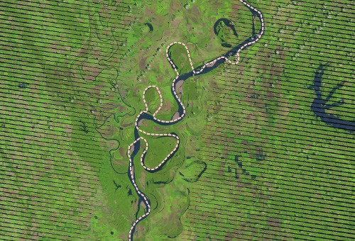
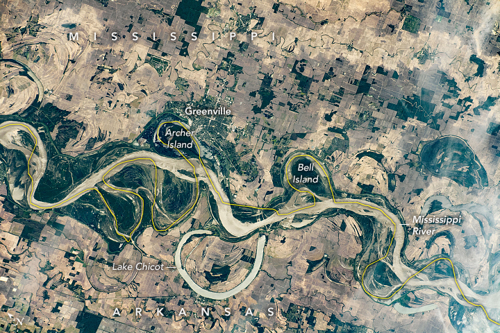
The U.S. is divided into 50 states, each with its own government and jurisdiction over many aspects of public policy. The boundaries of these states were established over centuries, influenced by factors such as colonial charters, geographic features, and historical treaties. For instance, the Mississippi River serves as a natural boundary for several states. In Figure 9.4.1 you see that the Mississippi River and the state boundary between Arkansas and Tennessee do not overlap. Over time, rivers tend to change their course so using a river as boundary is not always advisable. However,.state boundaries are fixed and clearly defined by the U.S. Constitution and state constitutions no matter what the course of any river is.
Source: “ISS062-E-121160.JPG” from NASA’s Earth From Space Image Collections.
The meandering Mississippi River has historically served as a boundary for numerous state lines in the United States. This image was captured by an astronaut on the International Space Station. Please note that North is to the left.
Subnational Boundaries – Counties:
Within each state, counties serve as the next level of administrative division. Counties in the U.S. vary widely in size and population, from Los Angeles County in California, which has a population larger than many states, to rural counties with fewer than a thousand residents. County boundaries often follow natural features but can also be straight lines drawn during the nation’s expansion westward.
Not every state in the U.S. uses the term “counties” for its primary administrative subdivisions.
- Louisiana: Uses “parishes” instead of counties. There are 64 parishes in Louisiana.
- Alaska: Uses “boroughs” and “census areas.”
Subnational Boundaries – Towns and Cities
The smallest formal administrative divisions are towns and cities. Their boundaries can be influenced by a variety of factors, including historical settlements, economic development, and geographic features. Urban boundaries often expand over time through annexation, reflecting the growth of a city and its suburbs. For example, the boundaries of cities like New York and Los Angeles have changed significantly over the decades due to urban sprawl and annexation of surrounding areas.
Unfortunately, the definitions of “city” and “town” in the United States can vary significantly from state to state, as each state has its own criteria and laws regarding these designations. Generally, though, here are some common distinctions:
City
- Legal Status: A city is typically an incorporated municipality with its own government and administrative structures. Incorporation is the legal process through which a community is officially designated as a city.
- Government: Cities usually have a mayor-council or city manager form of government, providing a higher degree of self-governance. They can pass ordinances, collect taxes, and provide a range of services.
- Population: Cities often have larger populations compared to towns, although the specific population threshold can vary by state.
- Services: Cities typically provide a wide range of services such as police and fire departments, public transportation, and extensive infrastructure.
Town
- Legal Status: A town is also an incorporated municipality, but it may have different legal standing and fewer powers compared to a city. The distinction between a town and a city can be based on state law and local charters.
- Government: Towns often have a simpler form of government, such as a town meeting system or a board of selectmen. The governance structure may involve more direct participation from residents.
- Population: Towns generally have smaller populations compared to cities, though again, the specific criteria can vary by state.
- Services: Towns might provide fewer services than cities, often relying more on county-level services for things like policing and infrastructure.
Variations by State
- New England: In states like Massachusetts and Connecticut, the term “town” has a very specific meaning and represents the primary local government entity, often with more powers than towns in other states. Cities in New England are typically larger and have adopted a city charter.
- New Jersey: In New Jersey, the term “town” has a specific legal meaning, and municipalities can be classified as cities, towns, boroughs, or townships, each with its own form of government.
- Virginia: In Virginia, cities are independent from counties, meaning they do not fall under county jurisdiction, while towns are part of counties and subject to county government.
General Observations
- Size and Scope: Generally, cities are larger and have more complex government structures than towns.
- Services Provided: Cities tend to offer a broader range of services directly, while towns may rely more on county or regional services.
- Governance: Cities often have a mayor-council or city manager system, whereas towns might have a more communal form of government, such as a town meeting.
9.4.2 Importance of Boundaries
- Administrative and Legal Functions: Boundaries delineate jurisdictions, determining which government has authority over a given area. This affects everything from law enforcement to school districts to taxation.
- Economic Implications: For instance, taxes, minimum wage laws, and business regulations can vary dramatically between neighboring states or cities, influencing where businesses choose to locate.
- Cultural and Social Identity: People often feel a sense of belonging to their city, state, or country, which can influence their behavior, values, and loyalties.
- Environmental Management: Effective environmental management often requires cooperation across boundaries. Watersheds, wildlife habitats, and ecosystems don’t adhere to human-made borders, necessitating collaborative efforts for conservation and resource management.
9.4.3 Challenges and Conflicts
Disputed Boundaries: Disputes over boundaries can lead to conflicts, as seen in international territorial disputes at this point (2024) between Ukraine and Russia or local disagreements over municipal annexations.
Changing Boundaries: Boundaries are not always permanent. Redistricting within countries can alter political landscapes, while urbanization can change city and county lines. Districts within counties change often, also.
Overlapping Jurisdictions: In some areas, multiple layers of government (e.g., city, county, and state) may have overlapping responsibilities, leading to complexity in governance and potential conflicts over authority and resources.
Challenges to State Sovereignty

Source: “Kashmir map” by Central Intelligence Agency (CIA) is in the public domain.
It is crucial to consider the question, “Who has the authority and capacity to delineate a boundary?” Take, for example, the contentious region of Kashmir, claimed by both India and Pakistan. In India, publishers are mandated to depict Kashmir on a map as part of India. In 2011, the Indian government directed the Economist magazine to either remove or obscure a map depicting Kashmir as divided between Pakistan, India and China (check Figure 9.4.3) in 28,000 copies of its May edition intended for sale in India. The Kashmir conflict has been the cause of two wars between the two countries both of which own nuclear weapons.
Even well-known multi-national companies like Google Maps are censored if they show the area as “disputed.” This means that Indians grow up always seeing Kashmir as a part of their country, of equal standing with undisputed states like Kerala or Assam. Any proposal to recognize Pakistani control over part or all of Kashmir would then provoke severe resistance from the Indian populace. Maps outside the disputant countries commonly show both boundaries, noting their disputed status. But this compromise is not neutral, as it sends a message that both claims are equally legitimate. (Imagine, for example, if Canada announced a claim to Washington State, and maps published outside North America began showing that state as a disputed territory!)
Exercise: Border Disputes
Visit this link and click on countries and yellow dots along borders to learn more about major ongoing border disputes: interactive disputed territories map.
Sovereignty in Maritime Spaces

Source: “UNCLOS-en” by Antonioptg via Wikimedia Commons is licensed under CC BY-SA 4.0.
The Earth’s surface is approximately 70% water, prompting the question: who holds ownership of the oceans? A maritime boundary is a conceptual division of the Earth’s water surface areas. As such, it usually defines areas of exclusive national rights over any natural resources within that boundary. UNCLOS, which stands for the United Nations Convention for the Law of the Sea, is the current governing agreement by which the majority of countries in theory abide. The chart above explains how sovereignty extends from a territory’s land borders into the sea. Of special note are the powers afforded to countries within territorial sea which include air, surface, and subsurface rights, and exclusive economic zones (EEZ), which include surface and subsurface rights.A maritime boundary is delineated at a particular distance from the coastline. Although in some countries the United Nations Convention on the Law of the Sea defines the boundary of international waters.
The videos below profile two hotspot maritime battlegrounds:
- the South China Sea, where countries in East Asia and Southeast Asia are vying for rights and human-made islands are being constructed to help assert sovereignty.
- the Arctic, where waterways are opening up because of the retreat of sea ice due to climate change, and Note how UNCLOS does and does not guide the actions of countries in these areas.
")
Source: “Sea of Japan naming dispute” by Qrsk075 via Wikimedia Commons is licensed under CC BY-SA 3.0.
In Figure 9.4.5 to the right the dispute is about the international name of the body of water marked with a “?”
Traditional name: Sea of Japan
Japan’s preference: Sea of Japan
North Korea’s preference: East Sea of Korea
South Korea’s preference: East Sea
Controversies about territorial waters tend to encompass two dimensions: (a) territorial sovereignty, which is a legacy of history; and (b) relevant jurisdictional rights and interests in maritime boundaries, which are mainly due to differing interpretations of the law of the sea. Many disputes have been resolved through negotiations, but not all.
